Transportation Data Archiving
This email address is being protected from spambots. You need JavaScript enabled to view it. - TRACC Director
Background
Urban and regional transportation planning and operations applications, (e.g. traffic modeling) require a large volume of accurate traffic-related data for a wide range of conditions. Significant real-time data on traffic volumes, highway construction, accidents, weather, airline flights, commuter and rail schedules, etc., are recorded each day by multiple agencies for each large urban transportation system. In some urban centers, the traffic-related information from multiple sources is integrated at a central information hub. This integrated data is used to optimize the current traffic operations, but it is not archived. The use of such historical traffic-related data would significantly benefit the development and validation of advanced computer models that can simulate complex transportation systems and the economic, environmental, and safety impacts of changes in these transportation systems.
Sensor Data for the Chicago Metropolitan Area
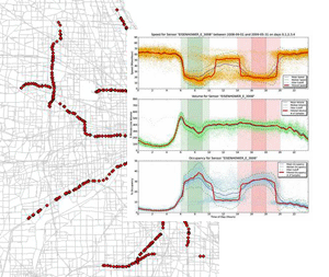 An important break-through during this time period was an evaluation of traffic sensor data electronically captured every 5 minutes from the GCM system (Gary-Chicago-Milwaukee Corridor). The capture was initiated in September 2008. The system has been capturing the data with few interruptions, caused by system maintenance on the cluster and some network outages. Nevertheless, the data consists of a nearly complete stream of 5 minute traffic volumes, speeds, and other data over a time period of 8 to 9 months. The scope covers 750 to 850 separate sensors, not all of which are active at all times (e.g. reversed lanes, road construction, connectivity, sensor failures, and similar). But the sensor data provides a wealth of information that can be used for calibration and validation of the TRANSIMS model of the Chicago Metropolitan Area, in particular with regards to the variations of traffic volumes by time of day.
The Role of High-Performance Computing
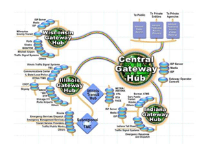 Advanced modeling, simulation, and visualization for transportation research and development require large-scale, high-performance data storage, management, and retrieval. Data gathering infrastructures in key urban areas, such as the Regional Intelligent Information Systems Infrastructure and the Information Gateway that supports the Gary-Chicago-Milwaukee Intelligent Transportation System Corridor, already exist and can be leveraged in the development of Traffic Information Archives.